
Ordnance Survey map navigation for ramblers in UK
A navigation app using the Ordnance Survey Maps for the United Kingdom.
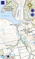
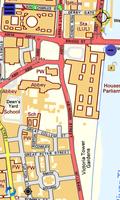
Gives access to OS maps scales 1:125000(roadmap),1:50000(Landranger), and 1:10000 (Streetmap)
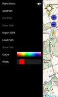
Features smooth scrolling, compass bearing, GPS route tracing, route paths, hand generated or imported from GPX files and waypoints.
Suitable for rambling, cycling or street level.
Search by postcode, placename, gridref or latitude/longitude
January 22, 2026
January 21, 2026
January 21, 2026
January 21, 2026
January 19, 2026
January 18, 2026
January 18, 2026
January 18, 2026
January 18, 2026
January 18, 2026
 Download APK(50MB)